Prepared April 3 to 7, 2012, en route, Cochin and Mormugao (Gao), India
March 19, 2012, Ha Long Bay to Hanoi:
The Road to Hanoi
We were finally cleared by Vietnamese immigration authorities; had our passports in hand; and took the tender ashore about 3:00pm. On disembarking from the tender at Bai Chay, we were met by our guide, Hoang Thuan. He escorted us to our vehicle, a Toyoda Highlander-type SUV, and we met our driver for the trip to Hanoi. There was still a heavy overcast with visibility greatly reduced by haze.
Our original plan -- to leave the ship, proceed to Noi Bai airport, and fly directly to Dien Bien Phu -- was shot. The last flight to Dien Bien Phu departed Noi Bai at 12:55pm. So, the revised plan was that we would drive to Hanoi, spend the night at the Hotel Metropole, and fly to Dien Bien Phu at 9:55am the next morning (March 20). This reduced our sightseeing time at Dien Bien Phu battlefields by half a day, but there really was no other option. And, spending the night at the Hotel Metropole in Hanoi had other advantages which will become apparent.
Heading east along National Route 18, passing through the Ha Long Bay resort area along the coast and turned inland toward Bac Ninh. We travelled through the villages and paddy fields that distinguish the Red River delta. It would take five hours to reach Hanoi, with a break mid-way at a village, Poi Moi, east of Bac Ninh. As we moved away from the coast, the cloud-cover lifted and the haze vanished. After driving about 2 1/2 hours, we stopped for a break at the largest tourist souvenir shop we have ever seen. It had every form of souvenir geegaw known to man. Starting at the high end -- Vietnamese emeralds and rubies, and proceeding to the low end -- logo key chains and refrigerator magnets.
A Few Stone Carvings for the Tourist
E Looks at Vietnamese "Newly Discovered" Rubies
NO! She did NOT!
According to our guide, this sourvenir shop had started as a venture of the the Humanity Center (Hong Ngoc) to provide training and employment for orphaned children who were picked up from the streets of Hanoi region. Other facilities at the site provided housing and meals for the children. The children produced some of the products sold, such as silk paintings, wood and stone carvings. The older children staffed the shop. Some children, because of extreme physical or mental disabilities, could not work at all and were in the care of this state-run organization. We spent a half hour stretching our legs, but overcame the temptations of rubies and refrigerator magnets!
Back in the SUV and on to Hanoi! Once we entered Bac Ninh (~15 miles northeast of Hanoi), the urbanization and industrial activity largely replaced paddy rice. Large, light industrial facilities followed one after another, many sporting globally-recognized logos like Sony, Canon, and Panasonic, to name but a few. Finally, we crossed a new bridge over the Red River and entered the northwest side Hanoi. We struggled through late-evening motorbike and automobile traffic to reach the Old Hanoi Quarter and the Hotel Metropole, which was originally opened in 1901.
When the SUV pulled up to the hotel's Opera Entrance, we were greeted by our Butler and escorted to the Executive Floors and club lounge, where the Butler collected our passports, filled in the forms, and made arrangements for a wakeup call, while we had juice and a cookie. (The equalitarianism of the new Communist states like Vietnam sometimes astounds you.) Declining going out to dinner because we were a little road weary, we were escorted to our suite, where after hot showers, a short night's sleep awaited us. We had to be on the move at 6:00am to catch our 9:55am flight to Dien Bien Phu from Noi Bai airport, which is about 25 miles from Hanoi's Old Quarter.
March 20, 2012, Ha Long Bay to Hanoi:
Finally, Dien Bien Phu -- Maybe
Northwest Vietnam (From Tourist Map)
Dien Bien Phu to right of Phong Saly, Laos -- Lower Left on map.
The alarm clock and wake-up call both sounded at about the same moment. 6:00am had arrived and it was all hands on deck! We had an excellent breakfast in the Executive Lounge at the Metropole (the best thing the French left in Vietnam was the bread, and the Vietnamese coffee is excellent!). Into the SUV and the 30-minute drive to Noi Bai Airport in rain and thick fog -- not a good sign. Arriving at the Vietnam Airlines Domestic check-in counter, we were informed that the flight (VN1702) scheduled for 9:30am was indefinitely delayed because of visibility at Dien Bien Phu. The airport at Dien Bien Phu is visual flight rules (VFR) only. After a two and one half hour wait, we were checked in, and boarded for the one-hour flight. Also, the Hanoi weather had improved -- rain had stopped and fog lifted.
The Vietnam Airlines ATR-72 took off from Noi Bai at 11:15am, and after clearing the low-cloud layer, the flight was uneventful. Dien Bien Phu is actually the name of an interior valley surrounded on all sides by mountains. The town of Dien Bien Phu is located on the east/central side of that valley; it is the Administrative Center of the Province bearing the same name that includes most of the northwestern portion of Vietnam along the Laos border. Dien Bien Phu is nearly equi-distant from Hanoi and Vientienne. In General Vo Nguyen Giap's account of the battle ("Dien Bien Phu," English Translation, The Gioi Publishers, 2011), the town (or more correctly, village of Dien Bien Phu) was known to the Vietnamese as Muong Thanh.
On Approach -- Dien Bien Phu

Dien Bien Phu (Valley) and French Fortified Camp
From: "Dien Bien Phu," Gen. Vo Nguyen Giap, The Gioi Publishers, 2011
When we began our descent into the valley, J could not help but think about what it was like for the French pilots flying C-47s from the same airfield (Hanoi's Noi Bai), along the same route, to the same Dien Bien Phu airfield in early 1954. (The airfield had been originally built by the Japanese in WWII.) Or, for that matter, the American pilots of China Air Transport (CAT) flying C-119s with the US Air Force markings scraped off and/or painted over to support the French. A lot more tense for sure than landing in an ATR-72 on a short runway in broad daylight without any anti-aircraft guns to focus your concentration. We landed on a recently-resurfaced runway, turned around and taxied to the newish terminal. No jumping out of airplane in the middle of the night, for old, silly American tourists! The Vietnamese closed the airfield by bringing it under direct artillery attack on March 27, 1954, and only air drops of supplies and personnel were possible until Dien Bien Phu fell on May 7, 1954.

Landing -- Dien Bien Phu
Walking across the apron to the terminal, just like in Kona, you could see the surrounding mountains on the east and west sides of the valley, but the ones to the north and south were lost in the haze. After collecting our luggage from the belt, the local authorities looked at our passports (upside down) and we were on our way to the parking lot to meet with our driver, Mr Tang, and our vehicle for the next four days, an all-wheel drive, diesel, Toyota Highlander SUV with oversized wheels, heavy-duty tires. Is this a hint of things to come? Our guide, Mr. Thuan, had flown with us from Hanoi and would be with us for our entire visit.
Dien Bien Phu Airport and Vietnam Airlines ATR-72
Before we began touring the battlefield sites, we drove to the Muong Thanh Dien Bien (MTDB) hotel to check in and have lunch. J & E had suggested that lunch was unnecessary, but the idea was met with no enthusiasm by our Vietnamese guide and driver. (Vietnamese do not miss meals! The whole idea of missing a meal is regarded as subversive Western behavior.) The MTDB hotel is the best hotel in Dien Bien Phu; however, the term "best" is relative. The thought that you might be getting into something unusual strikes you first when you see the vast amount of very colorful "yard art" that surrounds the hotel. J's favorite was the dragon that hung over the swimming pool. E tended to favor the African wild animals. The lobby and restaurants were fairly clean, and the food at lunch was good. Our guide did the ordering, and he stuck to a vegetarian and rice cuisine.
The room was another matter. It was, in the A&K tradition, to be a VIP suite. In fact, it was the "wedding suite" and unbelievably bizarre. The suite had two very large rooms (~20x20) with a large (~10'x12') bathroom. The rooms were tan from the floors to the 12 foot ceilings, all tan. The bathroom was black marble and lit by a single 12v fluorescent bulb -- very dark. (Not enough light in the bathroom to shave!) The bathroom had a fancy Jacussi tub, but it had never been plumbed, and a shower stall that delivered two water temperatures -- too hot and too cold -- with no place to put soap. The most prominent decorative item was a new ironing board and iron displayed in the bedroom -- bridal chamber. We wouldn't even speculate why it was there. Light was provided by tray fluorescent tubes that lit up the place like Walmart; and there were, what we supposed were electrical, wires hanging here and there about the rooms. Wonderful, wonderful! But the worst, as we found out on returning to MTDB that evening, was that the room was located on the 2nd floor, directly above the karaoke and disco bars (Zulu drumming) that played noise until 1:00am in the morning.
After lunch, we began our tour of the Dien Bien Phu battlefield sites. The first stop was the French Command Bunker, from where General de Castries and his staff operated. The five-room bunker was heavily protected and intact when de Castries surrendered the French Expeditionary Force, so you can now visit the interior, but there is virtually no explanation of the rooms' functions. J and E wanted to know in which room de Castries and three of his staff officers played bridge every evening during the siege, but no one seemed to know. The next stop was a preserved hulk of the US M-24 Chaffee tank loaned to France by the US. Almost every weapon used by the French at Dien Bien Phu had "Made in USA" stamped on them. For that matter, so did most of the Vietnamese.
The Battlefield and Campaign
From: "Dien Bien Phu," Gen. Vo Nguyen Giap, The Gioi Publishers, 2011
Gen. Castries Surrenders Outside Bunker, May 7, 1954
The Bunker Wall

Interior of French Command Bunker
Bridge Anyone?
J & E Outside French Command Bunker
The Obligatory Photo
US M-24 Chaffee Tank "Loaned" to the French
Maybe we should ask for it back and send it to Afghanistan.
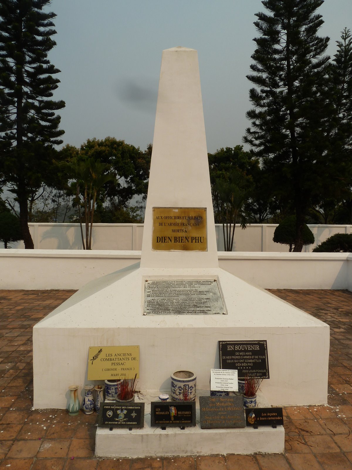
We then proceeded a short distance to the monument honoring the 7,000 French troops who died in the defense of Dien Bien Phu. The monument stands on the site of the mass burials conducted immediately after the fighting ended between May 8 to 10, 1954. The area around the monument was the site of the main French hospital bunkers (no longer in existence), where conditions became so bad by May that wounded men preferred to return to their units to die rather than drown in the rain water or from gangrene that riddled the bunkers.
Memorial to French Forces at French Cemetary
Next, we visited the Vietnamese Army Memorial and Cemetery. Names of all known soldiers killed in action are listed by district on bronze plaques covering the interior cemetery walls. Graves stones and graves inside the walled area are reserved for 650 unknown Vietnamese soldiers who died in the battle. There is a small shrine at the back of the cemetery where offerings of incense, flowers, and food are made. According to one of the ladies who tends the shrine, families of the soldiers still come to talk with the soldier's spirits. Like the US, the Vietnamese have an active forensic effort underway to identify unknowns. When a person is identified, his name is entered on the bronze plaque for his district, and his remains are disinterred and sent to his home district to be reinterred in the district's military cemetery. You see these military cemeteries everywhere in Vietnam. The official number of Vietnamese killed in the defeat of the French at Dien Bien Phu is listed as 20,000. Our guide said that General Giap has used the number 50,000, and others think it may have been as high as 70,000 men and women. Especially, when you consider the logistic support elements that faced unbelievable conditions to provide supplies to the combat units in and around the valley, the higher numbers are believable.

Vietnamese Military Cemetery
Bronze Plaque for One District with Names of Killed in Action
Markers for the Unknown Killed in Action
Statue Honoring the Families of the Fallen
Shrine to the Fallen with Offerings
Tree Planted by General Giap in Honor of the Fallen
On our way out of the Army Memorial and Cemetery, we met a group of six young (teenage) Vietnamese with their teacher who were making a video about Dien Bien Phu. They were carrying incense and flowers to make an offering at the shrine. A conversation ensued with our guide as translator, and there was mutual picture taking. The students all spoke English, so the conversation was often multisided. Finally, they asked if we would be in their movie. Being in the movie consisted of sitting on the boundary of one of the unmarked graves and all, except us, singing a patriotic Vietnamese song. We guessed our role was to be props or maybe the villians. But everyone seemed to be having a good time.
The Movie Makers with J and E
The next stop was the Battlefield site, which the Vietnamese call Hill A-1 and the French called position Elaine. It is the only part of the French fortifications at Dien Bien Phu that has been preserved and was where some of the very heavy fighting between the Vietnamese and French occured. Fighting for Hill A-1 was nearly continuous from March 30 until May 7, when the French garrison surrendered. There is a small museum at the base of the hill which features a three-dimensional, scale model of Hill A-1 showing the French wire, trenches, and bunkers. It also shows the Vietnamese approach trenches and tunnels, and the lines of attack. Having viewed the museum, we began our walk up a paved path to the top of Hill A-1 past the French positions. This was a heavily-fortified position, which was taken by direct assualt, so Vietnamese casualties must have been high.
The Battle for Hill A-l (Elaine)
From: "Dien Bien Phu," Gen. Vo Nguyen Giap, The Gioi Publishers, 2011
The Fight for A-1 Mural and Part of three-dimensional, scale model
On top of the position are four captured M-24 tanks, French trenches and bunkers, and a moument to the Vietnamese who died fighting there. Also, you can see the crater that a Vietnamese 1,000kg tunnel bomb caused. This bomb initiated the final assault on Hill A-1 on May 6.
French Trench, Hill A-1 (Elaine)

French Command Bunker, Hill A-1 (Elaine)
Walking down from the summit, you pass a scrapyard of destroyed French (American) weapons, including parts of aircraft, trucks and artillery pieces, and some Vietnamese Army weapons (mainly artillery and anti-aircraft guns of various types, including Russian, Chinese and American).
Scrap Metal Now -- Weapons Used in The Battle
Your Taxpayer Dollars at Work (Circa 1954)
US-made bombs with parts of crashed US-built aircraft in background.
After one last stop to see the new (2007) Vietnamese memorial to all the people who brought about the victory at Dien Bien Phu, we completed our tour of this Valley of Death, as Ted Morgan has named it in his recent book with the same title. If you are interested in a detailed account of the causes, events, and consequences of the battle, J recommends you read Ted Morgan's book, "The Valley of Death." The only major battlefield sites we did not visit, because of our shortened schedule, was General Vo Nguyen Giap's headquarters in Tham Pua Cave, outside of Dien Bien Phu. Most of the battlefield has returned to paddy rice or is covered in urban development, so the rest of the French positions can be seen only from a distance, unless you want to do some rice-paddy trekking.
2007 Monument to the Victory at Dien Bien Phu
The Statue is at the top of the Walk.
The rest of this long day was spent visiting a Black H'mong village about ten miles north of Dien Bien Phu off Route 12. It was early evening and very quiet; families were having dinner, and the only ones interested in us were the local dogs! The village seemed prosperous, with numerous new teak houses and many motor bikes. The H'mong women still wore their traditional black dresses and unique hats, while the males seemed to have adopted standard international fashion -- t-shirt and jeans. Returning to the SUV and the city, we walked through the large Central Market. Then, it was back to the Muong Thanh Dien Bien Hotel, and a night of karaoke and disco!
House Under Construction -- H'mong Village

Drying Rice on Concrete Road - H'mong Village
Why Did the Ducks Cross the Road or Did They?
What Are You Doing?
The Central Market -- Dien Bien Phu